
Travel and Geography
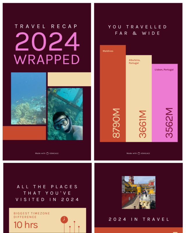
Travel Recap 2024 Wrapped, One Year of Trips in Four Panels
It counts 5 countries, 8 places and 3 continents visited, lists the Dominican Republic, Portugal, the United States, the Maldives and Canada, and names the…
This hub combines travel guides with the geography behind them, including the largest seas and lakes, islands, mountains, new countries, map projections, tourism and the rules for crossing borders. Each page credits the mapmaker, gives every place and figure as text and checks it against current sources. Readers often start with the 50 largest bodies of water, do's and don'ts in Germany, the Seven Summits and their heights, the true size of Africa map or the newest countries in the world since 1990.
It counts 5 countries, 8 places and 3 continents visited, lists the Dominican Republic, Portugal, the United States, the Maldives and Canada, and names the…

Cows and roses lead with 12 nicknames each, followed by apples with 9.

Montana Highway 200 is the longest of all at 706.5 miles, and District of Columbia Route 295 the shortest of them at 4.3 miles.
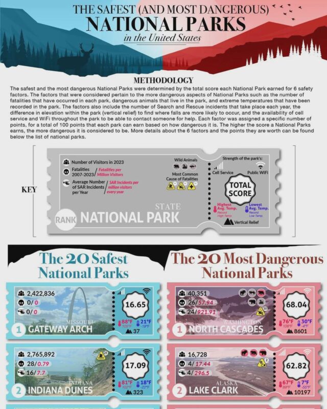
Gateway Arch in Missouri is safest with 16.65 points, followed by Indiana Dunes.

The Woolworth Building leads in 1920 at 792 feet, the Empire State Building at 1,250 feet dominates from 1940, and One World Trade Center reaches 1,776 feet…

You apply for ETIAS before travelling, the EES records you at entry and exit, and the 90/180 rule limits your stay to 90 days in any 180.

Nepal has the most, with 31 national public holidays in 2018, followed by Cambodia (30), Sri Lanka (28) and Iran (26).

The true size of Africa is about 30.3 million km², a fifth of the world's land and big enough to hold the United States, China, India, Japan and the whole…
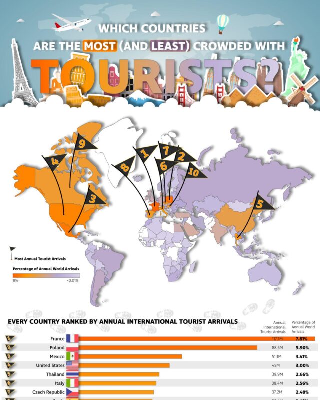
Turkey, Italy, Mexico, the UK, Germany, Japan and Greece complete the top 10.

Honshu in Japan is second with about 102.6 million and Great Britain third with about 66 million.
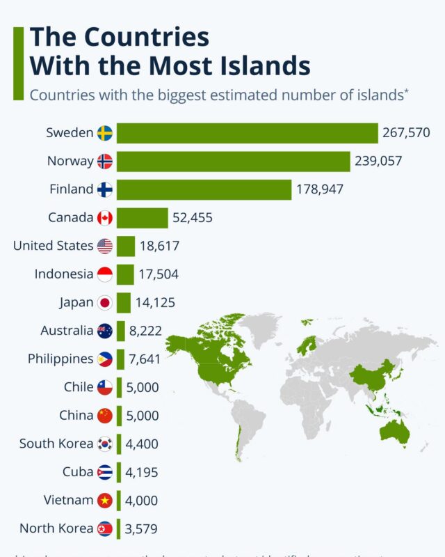
Norway is second with 239,057 and Finland third with about 198,000 on its latest count.

The main do's and don'ts in Germany are simple: shake hands when you meet people, use the formal Sie until invited to use du, be on time, and wait for…
Of the 17 infographics, the physical geography ones cover the largest oceans, seas, lakes and rivers, the countries with the most islands, the most populated islands and the highest peak on each continent. World maps show the newest countries since 1990, the true size of Africa and public holidays by country. Road charts rank all 77 US interstates by length and name each state's longest highway. Travel guides cover German etiquette, the Schengen entry rules, tourist arrivals by country and the safest and most dangerous US national parks. Lighter pieces cover traditional hats, plants and animals in US city nicknames, the New York skyline and one traveller's 2024 recap.
The 50 Largest Bodies of Water, Ranked by Size by Tower Paddle Boards puts the Pacific first at 60,000,000 square miles, the Caspian Sea is the largest lake at 143,000 square miles and the Nile is the longest river system at 4,130 miles. For islands, Statista's Country With the Most Islands, Top 15 Ranked gives Sweden an estimated 267,570.
Kai Krause's 2010 map, The True Size of Africa Map by Kai Krause, fits the United States, China, India, Japan and much of Europe inside Africa, and his table puts those 18 countries at 30.1 million km², just under Africa's 30.2 million km². Julie Peasley's Newest Countries in the World Since 1990, Mapped marks 31 countries, 15 of them from the break-up of the Soviet Union, with South Sudan, independent since 9 July 2011, the youngest.
For trip planning, the ETIAS Travel Authorization Europe Infographic, EES and 90/180 from 90-180.eu shows how three rules fit one trip. You apply for ETIAS before travelling, the EES records you at entry and exit, and a short stay means up to 90 days in any 180-day period. The EU says ETIAS is not yet in operation. The German Embassy in Washington's Do's and Don'ts in Germany, a Cultural Guide advises using the formal Sie until invited to use du and not starting to eat before others.
France, with 117.1M international tourist arrivals a year, or 7.81% of the world total, according to the Irish Dual Citizenship chart Countries With Most Tourists, All 185 Ranked by Arrivals. Poland, Mexico and the United States follow.
North Cascades in Washington is the most dangerous on Cocoweb's 100 point safety index, scoring 68.04. It had only 40,351 visitors in 2023 but 26 fatalities since 2007. Gateway Arch in Missouri is the safest, with 16.65.
Each page writes out the graphic in text and checks its claims against the sources listed on the page, with any mistakes corrected in a note. The 7 Summits of the World page, for example, corrects two label errors on the graphic.
Give it a permanent page where people looking for your subject find it, with your name and a link to your site. Content marketers, agencies, designers and researchers all list here.